
How aerial drone mapping and traditional ground-based methods compare on speed, cost, coverage, and safety, and how to decide which fits a given job.
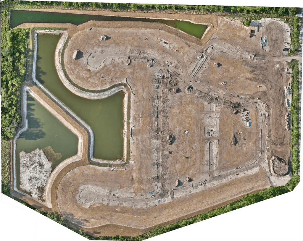
A construction manager deciding how to document a site has more options than a few years ago. Traditional ground-based methods are proven and precise where it counts. Aerial drone mapping covers the whole site quickly and safely, even at scale. Neither is the right answer for every job, and the smartest teams use both. This guide compares the two factor by factor, and lays out when each one fits across a Tampa Bay construction project.
This guide covers methods for site documentation. A survey of record, such as a boundary or a recorded topographic survey, is a regulated deliverable that requires a licensed Professional Surveyor and Mapper regardless of method, which the dedicated section below addresses.
The Two Approaches
Drone mapping captures a site from the air. A drone flies a programmed grid, and the imagery is processed into an orthomosaic map, a 3D model, and related documentation, usually within a day or two. Traditional methods capture a site from the ground, with crews using instruments to record points and features directly. Both produce a picture of the site. They differ in how that picture is captured, how fast, how completely, and at what cost and risk.
How They Compare
Speed
Drone mapping is fast. A site is flown in hours, and the processed map follows within 24 to 48 hours. Ground-based documentation of a large or complex site can take days, and on big acreage it can run into weeks of field time. On a project where the documentation needs to keep pace with the work, speed is often the deciding factor.
Cost
On a large or complex site, drone mapping is frequently lower in total cost, because it replaces days of field labor with a short flight and processing. On a small, simple site, ground methods can be perfectly economical. The larger and more complex the site, the more the cost comparison favors the drone.
Coverage and completeness
A drone grid captures the entire site uniformly, including the areas between the obvious points of interest. Ground documentation captures what the crew records, which is precise at each point but sparser across the site as a whole.
Safety
Drone mapping keeps people off the hazards, such as active traffic, heights, unstable ground, and equipment zones. Ground crews are exposed to those hazards by the nature of the work. On a busy or dangerous site, removing people from harm’s way is a real advantage.
Frequency and repeatability
A drone can re-fly a site weekly or biweekly at modest cost, which makes progress documentation practical. Repeating ground documentation that often is expensive and slow, so it tends to happen less frequently.
Data richness
Drone mapping produces a full visual map and a 3D model, and the same flight can add thermal or other data. Ground methods produce precise located points but a sparser overall picture. The two carry different kinds of value: breadth and visual context from the air, pinpoint precision at specific points from the ground.
Site disruption
A drone flight is minimally disruptive, since the pilot works from one spot and the flight is brief. Ground crews move through an active site over a longer period.
When Drone Mapping Is the Right Call
Drone mapping is the right call on large sites, where its speed and cost advantages are largest. It fits projects that need frequent progress documentation, sites that are hard or unsafe to access on foot, and any situation where stakeholders need a clear, current, visual record. When the goal is one current picture of the whole site that can be refreshed on a schedule, the drone is the tool.
When Traditional Ground Methods Still Make Sense
Ground methods still make sense on small, simple sites, where the overhead of a flight is not worth it, and wherever the need is direct, precise measurement of specific points rather than a picture of the whole site. Very dense canopy can also limit photographic aerial mapping, although aerial LiDAR addresses much of that, as the aerial LiDAR mapping pillar explains. And for any regulated survey deliverable, a licensed surveyor is required, which the next section covers.
When You Need a Licensed Surveyor
Neither drone mapping nor a ground documentation crew is a substitute for a licensed surveyor when the deliverable is a survey of record. Boundary determinations, plats, recorded topographic surveys, and anything sealed under Chapter 472 of the Florida Statutes require a licensed Professional Surveyor and Mapper. A surveyor may use drone-captured data inside their workflow, and Blue Nose Aerial Imaging of Tampa Bay supplies that aerial data to licensed firms, but the regulated survey itself is the surveyor’s deliverable. The drone survey article explains where the line falls and how aerial data supports licensed survey work.
Chapter 472 Notice
Blue Nose Aerial Imaging of Tampa Bay provides aerial imagery, photogrammetric data products, and related reporting services for informational, operational, and documentation purposes only. Our deliverables, including orthomosaics, 3D models, point clouds, cut/fill reports, and stockpile inventory reports, are not survey products and are not intended for use in legal boundary determinations, property conveyances, permitting requiring licensed survey work, or any application governed by Chapter 472, Florida Statutes. Clients requiring licensed surveying and mapping services should engage a Florida-licensed surveyor and mapper. Blue Nose Aerial Imaging of Tampa Bay is not a licensed surveying and mapping firm and does not represent itself as such.
How Construction Managers Combine Them
In practice, the question is rarely drone or ground. It is which tool for which part of the job. Construction managers use drone mapping for the routine, whole-site documentation and the progress record, because a single flight covers everything and can be repeated as often as the schedule needs. They use ground methods, and a licensed surveyor where required, for precise points and for the regulated deliverables. The two complement each other, and a provider who supplies clean aerial data that a survey crew or engineer can build on makes the combination work smoothly.
Where Blue Nose Aerial Imaging of Tampa Bay Maps
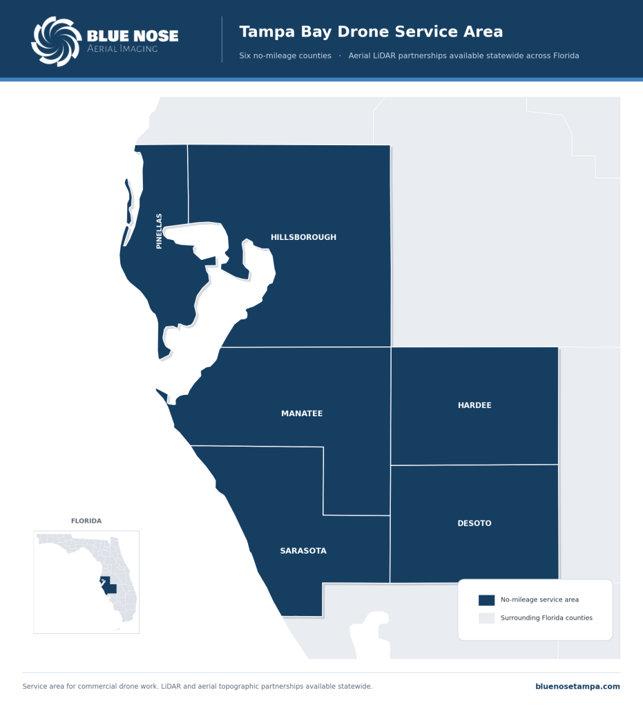
Blue Nose Aerial Imaging of Tampa Bay provides aerial mapping with no mileage charges across six counties: Pinellas, Hillsborough, Manatee, Sarasota, Hardee, and DeSoto.
For LiDAR partnership work with surveying firms, Blue Nose Aerial Imaging of Tampa Bay operates statewide across Florida. Other projects beyond the no-mileage area are scoped with travel factored in.
What It Costs and How to Start
Aerial data capture for construction site documentation typically ranges from $750 to $3,500 per site, depending on acreage, the deliverables, and whether the site is flown once or on a recurring schedule. Blue Nose Aerial Imaging of Tampa Bay provides a written scope and a price after a short scoping conversation.
Frequently Asked Questions About Drone Mapping vs. Traditional Mapping
Is drone mapping better than traditional mapping?
Neither is universally better. Drone mapping is faster, more complete across a whole site, safer, and easier to repeat, which makes it strong for construction documentation and progress tracking. Traditional ground methods offer pinpoint precision at specific points. Most construction teams use both, choosing the tool that fits each part of the job.
Is drone mapping cheaper than traditional methods?
It depends on the size of the job. On a big or complex site, the drone usually wins on total cost, since one short flight and processing stand in for days of crew time in the field. On a small, simple site, the overhead of a flight is not worth it, and ground methods come out ahead.
Is drone mapping accurate enough for construction?
For construction documentation, progress tracking, verification against plans, and stakeholder reporting, aerial mapping captured under controlled field conditions is reliable and widely used. It is operational documentation, not a sealed survey, and it is not used for boundary or permitting purposes that require licensed survey work. For those, a licensed surveyor is required.
Can drone mapping replace a surveyor?
No. For a survey of record, such as a boundary, a plat, or a recorded topographic survey, a licensed Professional Surveyor and Mapper is required regardless of whether the data is captured by drone or ground crew. Drone mapping replaces or supplements ground-based methods for site documentation, not the licensed survey itself. A surveyor may use drone data inside their workflow, but the regulated deliverable remains theirs.
How often can we map a site with a drone?
As often as the work calls for. Weekly or every other week is common on an active site, since a re-flight is quick and inexpensive. That ease of repeating is one of the clearest edges drone mapping has over ground methods for progress records.
What does drone mapping cost?
Aerial site documentation generally runs $750 to $3,500 per site. Acreage, the deliverables, and whether the site is flown once or on a schedule set where it lands, and a program that runs across the life of a build is quoted as an ongoing arrangement.
Request a Drone Mapping Quote

Rob Smith
Director of Operations, FAA Part 107 certified
Every drone mapping project starts with a quick conversation. Rob Smith, our Director of Operations, will help you scope the right approach for your site and answer your questions on a call.
What to expect on the call:
- We learn about your site and what you need to document.
- We recommend the right mapping approach and cadence.
- You get a clear, no-pressure quote.
You can also reach the team at 941-376-3396.