")
A Buyer’s Guide for Construction PMs and Surveying Firms
Serving Pinellas, Hillsborough, Manatee, Sarasota, Hardee, and DeSoto Counties for commercial drone services, and statewide for LiDAR partnerships with Florida-licensed surveying firms.
Before anything else, here is the most important thing for any construction PM, surveying firm, civil engineer, or commercial property manager evaluating drone survey services in Florida to understand. The practice of surveying and mapping is regulated under Chapter 472 of the Florida Statutes, and only a person registered with the Florida Board of Professional Surveyors and Mappers may legally perform, or advertise that they perform, surveying and mapping services as defined in section 472.005, Florida Statutes.
Blue Nose Aerial Imaging of Tampa Bay is not a licensed surveying and mapping firm under Chapter 472. We provide FAA Part 107 commercial drone services, including aerial imagery, photogrammetric data products, LiDAR scans, orthomosaic maps, point clouds, and thermal inspections, for informational, operational, and documentation purposes. Our deliverables are not survey products, and they are not intended for use in legal boundary determinations, property conveyances, or any application that requires licensed survey work.
The reason this comes first is that the search term “drone survey” gets used loosely. Construction project managers, surveying firms, civil engineers, and commercial property managers searching it are usually trying to solve one of three different problems, and only one of those problems requires a licensed surveyor. The other two are exactly what commercial drone services are built for. This article will help you tell the difference, decide what your project actually needs, and understand what aerial data products can do for your business across Tampa Bay and the surrounding Florida counties.
What Commercial Buyers Actually Mean When They Search “Drone Survey”
In our work with construction project managers, civil engineers, Florida-licensed surveying firms, commercial property managers, and facility directors across Pinellas, Hillsborough, Manatee, Sarasota, Hardee, and DeSoto Counties, the phrase “drone survey” almost always means one of the following three things.
1. A legally recorded land survey, performed by a Florida-licensed surveyor
This is the regulated practice defined in section 472.005, Florida Statutes. The statute enumerates the activities reserved to licensed surveyors and mappers, including boundary monumentation and remonumentation, preparation of legal descriptions for conveyance, subdivision planning maps and record plats, determination of grades and elevations for roads and land in subdivisions, and the preparation of plans, plats, field notes, reports, and property descriptions that fall under those activities. If your project needs a boundary determination for a property line dispute, a survey for a real estate transaction, a plat for permitting, or any document that will be sealed and signed by a Professional Surveyor and Mapper, you need a Florida-licensed surveyor. Drones may be used as a tool inside that surveyor’s workflow, but the survey itself is a regulated deliverable that only a licensed firm can produce.
Blue Nose Aerial Imaging of Tampa Bay does not provide this. If this is what your project needs, we will refer you to licensed surveying firms in your county.
2. Aerial data capture in support of survey work
This is where many surveying-firm inquiries actually land. A Florida-licensed surveying firm has a project that involves heavy tree canopy, dense brush, or terrain that would take a ground crew a full week to walk. The firm needs the same project completed in a few days at a competitive price point. They engage Blue Nose Aerial Imaging of Tampa Bay as a subcontract aerial partner. We fly the site, process the data, and deliver a classified point cloud, an orthomosaic map, or a contour deliverable that the surveying firm then folds into their own survey deliverable under their seal.
The surveyor remains the licensed professional of record. Blue Nose Aerial Imaging of Tampa Bay provides the aerial data layer that makes the firm’s job faster, cheaper, or possible at all on terrain where conventional methods do not pencil. This is what our LiDAR program was built around. Surveying firms across the Tampa Bay and Central Florida region engage us this way, from St. Petersburg and Clearwater in Pinellas, to Tampa and Brandon in Hillsborough, to Bradenton and Lakewood Ranch in Manatee, to Sarasota and Venice, out to the ranch and agricultural country of Hardee and DeSoto.
3. Aerial mapping for construction, commercial property documentation, or operations
This is the third bucket, and it is the biggest by project volume. A construction superintendent needs a high-resolution map of an active job site to compare against the civil drawings before a major pour. A general contractor needs documented site conditions for stakeholder reports and subcontractor management. A commercial property manager needs a documented baseline of a multi-building campus for operational reporting. A facility director at a logistics or industrial site needs a high-resolution aerial dataset for capital planning. A roofing contractor needs aerial documentation of a commercial roof for an insurance claim.
None of these workflows require a licensed surveyor. They require accurate, well-controlled, properly processed aerial data that supports operational decisions, documentation, and stakeholder reporting. This is the core of what Blue Nose Aerial Imaging of Tampa Bay delivers for commercial buyers across Tampa Bay.
How to Tell Which Service Your Project Actually Needs
A short set of questions usually resolves the ambiguity for any commercial buyer evaluating drone survey services.
- Will this document be filed with a government agency, recorded in public records, or used as the basis for a property transaction or permitting decision that requires a survey of record? If yes, the project needs a Florida-licensed surveyor. No exceptions.
- Does the project require a sealed and signed deliverable from a licensed Professional Surveyor and Mapper? If yes, the project needs a licensed surveyor. Aerial data alone is not a survey under Florida law, no matter how well captured.
- Is the goal to make operational, construction, or documentation decisions from aerial data? If yes, whether that means verifying work before it becomes permanent, documenting site conditions for stakeholder reports, tracking inventory, inspecting commercial roofs, or supporting a surveying firm’s existing workflow, aerial data is the right tool, and a licensed survey is not what the project needs.
If your team is still unsure, the safe call is to ring a Florida-licensed surveying firm and describe the project. They will tell you in two minutes whether the work requires a regulated survey or something different. Several surveying firms across Tampa Bay and Central Florida refer aerial data work to Blue Nose Aerial Imaging of Tampa Bay, and several of them subcontract aerial data capture from us. Either way, the licensed professional is the one who should rule on whether the project requires a survey of record.
What Aerial Data Products Actually Are (and Why They Get Confused with Surveys)
The confusion between “drone survey” and “aerial data” exists for a real reason. The technology is the same. The drones, the cameras, the LiDAR sensors, and the processing software are the tools Florida-licensed surveyors increasingly use to perform their regulated work, and they are also the tools commercial drone operators use to produce data products for unregulated applications.
The difference is not the equipment. The difference is who is signing off on the deliverable, what the deliverable is intended for, and whether it carries the legal authority of a sealed survey.
Here is what aerial data products actually are, in plain language commercial buyers can use to scope their projects.
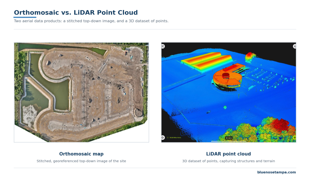
Orthomosaic maps
A single high-resolution aerial image of a site, stitched together from dozens or hundreds of overlapping drone photos and geometrically corrected so every pixel corresponds to its real-world location on the ground. This is the most common deliverable for construction site documentation, commercial property reporting, and pre-survey reconnaissance. It looks like Google Earth, except captured the morning you flew it, at high resolution. It is a documentation product, not a survey.
Point clouds
A three-dimensional dataset of millions of individual points, each carrying real-world coordinates and elevation. It is produced either from photogrammetric processing of drone imagery or from a LiDAR sensor mounted on the drone, and it serves as the foundation for 3D models, contour generation, surface modeling, and inventory analysis. Florida-licensed surveyors use point clouds as inputs to their survey workflows. Blue Nose Aerial Imaging of Tampa Bay produces point clouds as deliverables that other professionals, such as surveying firms, civil engineers, and construction managers, use as inputs to their own work.
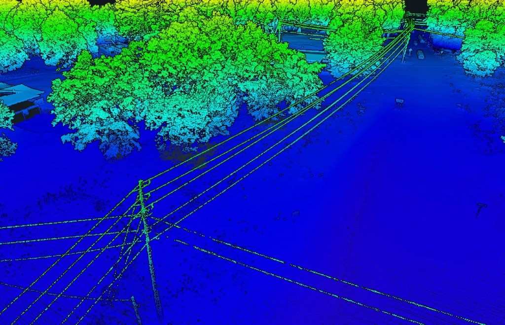
LiDAR scans
A specific kind of point cloud produced by a laser sensor that measures distance by timing the return of laser pulses. The advantage of LiDAR over photogrammetry is that the laser penetrates vegetation, including tree canopies, dense brush, and tall grass, and captures the ground surface beneath. In Florida, where so many sites are wooded or vegetated, this is the difference between a viable project and an impossible one. It is the foundation of our partnership work with Florida-licensed surveying firms statewide.
Cut-and-fill data and stockpile inventory reports
Numerical reports generated from point cloud data showing earthwork progress between two flights, or stockpile inventory estimates for materials on site. Construction project managers and superintendents use these to verify deliveries against tickets, track earthwork progress, and document subcontractor claims. They are operational documents, not survey reports.
Thermal and multispectral data
Sensor data captured by specialized payloads, including radiometric thermal sensors for commercial roof and building envelope inspections and multispectral sensors for vegetation analysis. These produce visual maps of temperature differentials or plant health metrics, not geometric or boundary information. Facility directors and commercial property managers commonly use them for capital planning and insurance documentation.
Drone Survey Use Cases for Commercial Buyers Across Tampa Bay and Central Florida
Across the six no-mileage counties, which are Pinellas, Hillsborough, Manatee, Sarasota, Hardee, and DeSoto, most of the “drone survey” inquiries Blue Nose Aerial Imaging of Tampa Bay receives fall into a few recurring kinds of work. Each one has different requirements, different deliverables, and a different relationship to the Chapter 472 question.
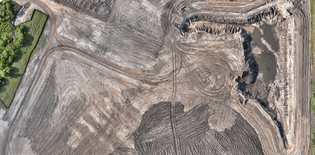
Construction site mapping and progress documentation for general contractors
This is the largest category by project volume. A general contractor or construction manager needs an accurate, time-stamped, georeferenced map of an active job site, refreshed weekly or biweekly, that overlays directly onto the civil drawings. The site might be a 40-acre commercial development in Hillsborough County, a multi-building commercial project in Manatee, an infrastructure expansion in Sarasota, or an agricultural or industrial site out in Hardee or DeSoto.
The workflow looks like this. Blue Nose Aerial Imaging of Tampa Bay flies the site early in the day, captures both visible-light imagery and any specialized data the project needs, processes the data through photogrammetric software, and delivers an orthomosaic map and a 3D model within 24 to 48 hours. The project superintendent uses the map to verify work before it becomes permanent, comparing concrete footing placement to plans before the pour, checking foundation alignment, validating utility trenching against design, and documenting stockpile inventory against delivery tickets.
The deliverable is not a survey. It is documentation. It does not establish boundaries, certify elevations for permitting, or carry the legal authority of a sealed survey product. What it does is replace a folder of cell phone photos with a single map a project manager can use to make decisions, support stakeholder reports to ownership, and resolve disputes about what was built where and when.
LiDAR partnership work for Florida-licensed surveying firms
This is the smaller-volume, higher-value bucket. A Florida-licensed surveying firm has a project where the site characteristics, such as heavy canopy, dense vegetation, scale, or terrain, make conventional ground-based methods uneconomical. The firm needs a one-foot contour deliverable on a 40-acre Florida site. Conventional methods can produce it, but the field time makes the price untenable for most projects.
Aerial LiDAR closes that gap. A properly controlled and processed mission with a current-generation enterprise LiDAR payload delivers a classified point cloud and the contour deliverable in days, not weeks, at a price point the surveying firm can quote competitively. The firm remains the licensed professional of record. Blue Nose Aerial Imaging of Tampa Bay provides the aerial data layer. The final deliverable goes to the surveying firm’s client under the surveying firm’s seal.
This partnership model works because the regulated practice, the survey itself, stays with the licensed firm. The aerial data capture, which is not regulated under Chapter 472, sits with the aerial provider. Surveying firms across the six-county area engage Blue Nose Aerial Imaging of Tampa Bay this way when the project economics or site conditions justify it. The LiDAR program also operates statewide for partnerships outside the no-mileage area, on projects where the economics support travel.
Commercial property documentation for facility directors and property managers
The third category covers a wide range of operational documentation needs that do not require licensed survey work. Commercial property managers use aerial documentation to establish a pre-storm baseline before hurricane season. Developers use it during due diligence to understand site conditions before going under contract. Facility directors at logistics, industrial, or multi-building campus operations use it for capital planning and operational reporting. Insurance adjusters use it after a storm event to document conditions for claims processing. Roofing contractors use it to document commercial roof conditions for insurance claims and warranty work.
None of this requires a survey. All of it benefits from accurate, well-controlled, time-stamped aerial data captured by a commercial operator who knows what they are doing.
How to Evaluate a Drone Survey Provider in Florida
The market for commercial drone services has a wide range of operator quality. The barrier to entry is genuinely low, amounting to a Part 107 certificate, a five-thousand-dollar quadcopter, and a few hours of YouTube. That means deliverable quality and operator credibility vary widely, and the burden of vetting falls on the firm hiring the work.
Five things actually matter when a construction PM, surveying firm, or commercial property manager is evaluating a drone provider for project work across Florida.
- Licensing and Chapter 472 clarity. FAA Part 107 is the legal minimum for commercial drone operations. Beyond that, look for documented training, recurrent certification intervals, and a written safety management system. If the provider offers work adjacent to surveying, they should be able to state clearly what they do and do not do under Chapter 472. Any operator who blurs that line is creating legal exposure for the firm hiring them.
- Insurance. Commercial liability insurance with at least two million dollars in coverage is the floor for any commercial drone provider. Additional insured certificates available per project is the standard for working on commercial construction sites and commercial properties.
- Equipment grade and obsolescence policy. Look for industry-leading sensors and platforms, refreshed on a defined cycle rather than used until they fail. The commercial drone equipment market refreshes on a two to three year cycle, and operators who have not updated equipment in five years are using sensors that produce noticeably different deliverables than current platforms.
- Documentation discipline. A professional drone operator delivers mission documentation alongside the data, including flight parameters, ground control configuration, processing notes, and a written description of what the deliverable is and is not. That documentation is what makes the aerial data product useful to engineers, surveyors, and project stakeholders who consume it downstream. Hobbyist operators rarely produce it.
- Industry credibility beyond drones. Aviation training, formal safety qualifications, and operational experience outside the consumer drone market are signals that the operator treats this as a profession. Our Director of Operations holds a master’s degree in Aeronautics with a specialization in Aviation Human Factors, an FAA Part 107 remote pilot certificate, and a current Airline Transport Pilot certificate as a 747 captain. The standards we fly under come from commercial aviation, not from a YouTube tutorial.
Where Blue Nose Aerial Imaging of Tampa Bay Operates Across Florida
Blue Nose Aerial Imaging of Tampa Bay operates across a six-county no-mileage service area covering Tampa Bay and the surrounding corridor. Within these counties, we do not charge mileage on project work.
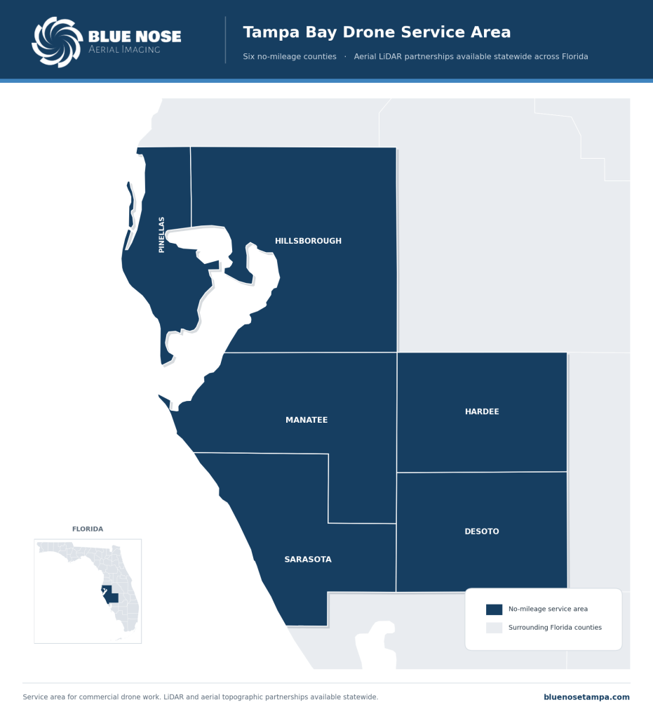
For higher-value LiDAR and aerial topographic data partnership work with Florida-licensed surveying firms, Blue Nose Aerial Imaging of Tampa Bay operates statewide across Florida. Surveying firms anywhere from the Panhandle to the Keys can engage us as a subcontract aerial partner on projects where the economics support travel.
What Happens When You Engage Blue Nose Aerial Imaging of Tampa Bay
Blue Nose Aerial Imaging of Tampa Bay starts every commercial engagement with a fifteen-minute scoping conversation to understand what the project actually needs. Three outcomes are possible from that call.
If the project requires a licensed survey under Chapter 472, we tell you so and refer you to licensed surveying firms in your county. We do not try to talk anyone into hiring us for work we are not qualified to do.
If the project is aerial data capture in support of a Florida-licensed surveyor’s existing workflow, we provide a written scope, a clear deliverable specification, and a price. The surveying firm remains the professional of record, and we work behind their seal.
If the project is aerial data capture for construction, commercial property documentation, commercial roof inspection, or any other operational use, we provide a written scope and a price covering the flight, the processing, and the deliverable format your team needs.
Most quotes go out within 24 hours of the scoping call. Most projects can be flown within five to seven business days of acceptance, subject to weather and airspace authorization windows.
Frequently Asked Questions About Drone Surveys in Florida
Is a drone survey the same as a land survey?
No. A land survey in Florida is the regulated practice of surveying and mapping under Chapter 472 of the Florida Statutes, and it may only be performed by a Florida-licensed Professional Surveyor and Mapper. A “drone survey” performed by a commercial drone operator is aerial data capture, such as orthomosaic maps, point clouds, LiDAR scans, or thermal imagery, captured under FAA Part 107 authority and not intended for legal boundary, conveyance, or permitting purposes that require a licensed survey.
Can a drone operator perform a land survey in Florida?
Only if the drone operator is also a Florida-licensed Professional Surveyor and Mapper, or operating under the supervision of one. The drone is a tool. The survey itself is a regulated deliverable. Commercial drone operators who are not licensed surveyors may capture aerial data and deliver it to a licensed surveyor as input to that surveyor’s workflow, but they may not produce a survey deliverable themselves.
What is the difference between a drone survey and aerial mapping?
“Aerial mapping” is the broader category, and it is not regulated under Chapter 472. It covers the production of orthomosaic maps, 3D models, and other aerial documentation products that do not carry the legal authority of a sealed survey. “Drone survey” is colloquial usage that can refer to either a true land survey performed using drones, which is regulated, or aerial data capture intended to look like or support a survey, which is not.
How much does a drone survey cost in Florida?
Pricing depends on what the deliverable actually is. Aerial data capture for construction site documentation typically ranges from $750 to $3,500 per site depending on acreage, sensor type, and deliverable format. LiDAR partnerships with Florida-licensed surveying firms typically range from $2,500 to $9,500 per mission for projects in the 10 to 50 acre range. A licensed land survey under Chapter 472 is a separate service performed by a licensed firm, and pricing varies by survey type.
Does a construction PM need a licensed surveyor for site mapping?
Usually not. Construction site documentation, including progress mapping, stockpile inventory reporting, pre-pour layout verification, and earthwork tracking, is operational documentation, not a survey of record. A licensed surveyor is needed when the project requires sealed survey documents for permitting, when boundaries are being established or contested, or when the deliverable will be recorded in public records.
Does Blue Nose Aerial Imaging of Tampa Bay work with licensed surveying firms in Florida?
Yes. Our LiDAR program exists as a subcontract partnership for Florida-licensed surveying firms: the firm stays the licensed professional of record and seals the work, while Blue Nose Aerial Imaging of Tampa Bay flies and processes the aerial data the firm builds on. Firms across Tampa Bay and statewide use it on canopy-heavy or large-acreage jobs where ground methods do not pencil.
What counties does Blue Nose Aerial Imaging of Tampa Bay serve for commercial drone surveys?
The no-mileage area is six counties: Pinellas (St. Petersburg, Clearwater), Hillsborough (Tampa, Brandon), Manatee (Bradenton, Lakewood Ranch), Sarasota (Sarasota, Venice, North Port), Hardee (Wauchula, Bowling Green), and DeSoto (Arcadia). For LiDAR and aerial topographic data partnerships with Florida-licensed surveying firms, Blue Nose Aerial Imaging of Tampa Bay works statewide across Florida.
Can drone-captured aerial data be used for commercial insurance claims?
Yes, for documentation purposes. Pre-storm and post-storm aerial inspections of commercial properties produce time-stamped, GPS-tagged documentation of property conditions that insurance adjusters increasingly accept as part of the claims process. The aerial data documents conditions, but it does not certify them in the legal sense that a sealed survey would. For claims that involve boundary disputes, sealed elevation certifications, or other survey-of-record questions, a licensed surveyor remains necessary.
Request a Project Quote
Rob Smith
Director of Operations, FAA Part 107 certified
Every project starts with a quick conversation. Rob Smith, our Director of Operations, will help you scope the right aerial data package and answer your questions on a call.
What to expect on the call:
- We learn about your site and what you need to capture.
- We recommend the right aerial data package and timeline.
- You get a clear, no-pressure quote.
You can also reach the team at 941-376-3396.
Chapter 472 Notice
Blue Nose Aerial Imaging of Tampa Bay provides aerial imagery, photogrammetric data products, and related reporting services for informational, operational, and documentation purposes only. Our deliverables, including orthomosaics, 3D models, point clouds, cut/fill reports, and stockpile inventory reports, are not survey products and are not intended for use in legal boundary determinations, property conveyances, permitting requiring licensed survey work, or any application governed by Chapter 472, Florida Statutes. Clients requiring licensed surveying and mapping services should engage a Florida-licensed surveyor and mapper. Blue Nose Aerial Imaging of Tampa Bay is not a licensed surveying and mapping firm and does not represent itself as such.