
How a licensed surveying firm engages Blue Nose Aerial Imaging of Tampa Bay for aerial LiDAR, who is responsible for what, and how the data arrives ready to incorporate under your seal.
A surveying firm does not need to own a LiDAR sensor to offer LiDAR deliverables. The firm needs the data, captured correctly and delivered in a usable form, and it needs to stay the licensed professional of record on the work. That is what a subcontract aerial partnership provides. Blue Nose Aerial Imaging of Tampa Bay flies and processes the LiDAR, and the firm incorporates the result into its own sealed deliverable.
That arrangement only works because the regulatory line is clean. Under Chapter 472 of the Florida Statutes, the practice of surveying and mapping in Florida is reserved to a licensed Professional Surveyor and Mapper, so the survey itself stays with the firm. Blue Nose Aerial Imaging of Tampa Bay is not a licensed surveying and mapping firm, and the aerial data it provides is not a survey; it is an input the firm seals into its own deliverable as the professional of record. This guide covers why firms outsource LiDAR, how the partnership is structured, who is responsible for what, and how the workflow runs. The technical side, what LiDAR captures under Florida’s canopy and the deliverables it produces, lives in the aerial LiDAR mapping pillar; this guide stays on the business arrangement.
Why a Surveying Firm Outsources LiDAR
Owning aerial LiDAR is a real commitment. A current enterprise sensor and drone platform is a significant capital purchase, the equipment market refreshes every few years, the processing requires software and trained staff, and keeping a pilot current adds ongoing cost. For a firm that needs LiDAR only occasionally, or that wants to add it without building the capability in-house, that math rarely works.
A subcontract partnership solves several problems at once. It turns a capital purchase into a per-project cost. It puts the flying, the sensor, and the processing in the hands of a dedicated aerial operator. It gives the firm capacity during busy periods without hiring. And it lets the firm take on canopy-heavy or large-acreage jobs that conventional methods cannot price, so the firm can compete for work it would otherwise pass on.
The Subcontract Partnership Model
The surveying firm holds the client relationship and the professional responsibility. Blue Nose Aerial Imaging of Tampa Bay works behind the firm as the aerial data partner. Blue Nose Aerial Imaging of Tampa Bay captures and processes the LiDAR and delivers the data products the firm specifies, and the firm folds them into its survey deliverable under its seal. The regulated practice, the survey itself, stays entirely with the licensed firm. The aerial data capture, which is not regulated under Chapter 472, is the part Blue Nose Aerial Imaging of Tampa Bay performs.
Who Is Responsible for What
The division of responsibility is clear from the start of every engagement.
The surveying firm owns the client relationship, defines the project requirements and the deliverable specification, establishes or directs the ground control, applies professional judgment to the data, and produces and seals the final survey deliverable. The firm is the professional of record.
Blue Nose Aerial Imaging of Tampa Bay plans and flies the LiDAR mission to the firm’s specification, captures the data under controlled field conditions tied to the ground control, processes the point cloud, and delivers the agreed data products in the formats the firm requested. Blue Nose Aerial Imaging of Tampa Bay does not seal deliverables, does not interact with the firm’s client unless the firm asks, and does not represent itself as a surveyor.
How the Workflow Runs
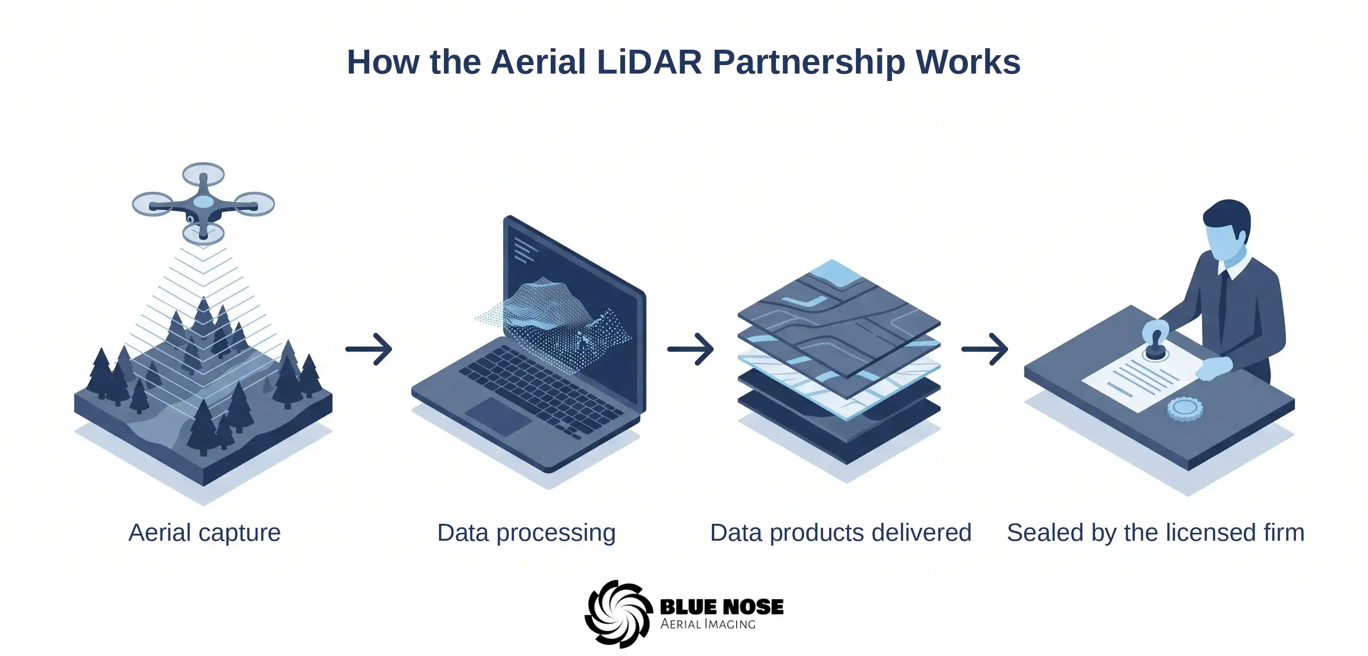
A typical engagement runs in a few clear steps.
Specify the deliverable
The firm specifies what it needs: a classified point cloud, a bare-earth terrain model, contour data at a stated interval, and the file formats its software requires.
Coordinate ground control
Ground control is established on the site so the aerial data can be tied to known points and checked against them.
Fly and process
Blue Nose Aerial Imaging of Tampa Bay flies the mission with the overlap and point density the deliverable requires, processes and classifies the point cloud, and generates the requested products, quality-checked against the control.
Deliver and incorporate
The firm receives the deliverables in its specified formats and incorporates them into the sealed survey product for its client.
The LiDAR point cloud processing guide covers those processing steps in detail, for firms and engineers who want to see what happens to the data between capture and delivery.
Working Behind Your Seal
Blue Nose Aerial Imaging of Tampa Bay operates as the back-end aerial partner, not as a competitor for the firm’s client. The client relationship, the brand, and the seal belong to the firm. Blue Nose Aerial Imaging of Tampa Bay is comfortable working under confidentiality where the firm prefers it, and the standard posture is that Blue Nose Aerial Imaging of Tampa Bay supplies data to the firm and the firm presents the finished, sealed work to its client. Firms that want a dependable LiDAR capability without building one, and without handing their clients to another vendor, are exactly who this model is built for.
Turnaround
The practical appeal of aerial LiDAR is speed, and the partnership is structured to preserve it. A site that would take a ground crew a week or more can often be flown in a day, with the processed deliverables following within a timeframe set during scoping. That turnaround is frequently what lets a firm quote a competitive schedule on a job that conventional methods would stretch out.
What It Costs
LiDAR partnership missions typically range from $2,500 to $9,500, depending on acreage, point density, the deliverables, and site conditions. The LiDAR drone survey cost guide breaks those factors down in detail.
Frequently Asked Questions About Drone LiDAR Services
What are drone LiDAR services for surveying firms?
Drone LiDAR services are aerial data capture and processing that a surveying firm engages on a subcontract basis. Blue Nose Aerial Imaging of Tampa Bay flies the LiDAR mission, processes the point cloud, and delivers terrain data and contour products in the firm’s specified formats. The firm incorporates that data into its own sealed survey deliverable and remains the professional of record.
Does Blue Nose Aerial Imaging of Tampa Bay seal or certify the LiDAR data?
No. Blue Nose Aerial Imaging of Tampa Bay provides aerial data products and does not seal or certify them. Sealing and certification are the responsibility of the licensed surveyor or engineer who incorporates the data into their deliverable. Blue Nose Aerial Imaging of Tampa Bay is not a licensed surveying and mapping firm.
Who is the professional of record on a LiDAR partnership project?
The surveying firm, always. It owns the client, brings the professional judgment, and signs and seals the finished deliverable. Blue Nose Aerial Imaging of Tampa Bay only performs the aerial data capture, which Chapter 472 does not regulate, and stays behind the firm.
What does my firm need to provide?
Two things, mainly: the project requirements and deliverable spec, including the file formats you want, and the ground control, which you set or direct. From there Blue Nose Aerial Imaging of Tampa Bay handles the planning, flying, processing, and delivery to that spec. The sharper the spec up front, the cleaner the handoff at the end.
Will Blue Nose Aerial Imaging of Tampa Bay contact my client?
Not unless you want us to. The default is simple: Blue Nose Aerial Imaging of Tampa Bay hands the data to your firm, and your firm presents the finished, sealed work to the client. Where you would rather keep the arrangement confidential, that is fine.
How fast is a LiDAR partnership project?
Fast enough to be the selling point. A site that takes a ground crew a week or more often flies in a day, and the processed deliverables follow on a timeframe agreed during scoping. That speed is much of why firms reach for aerial LiDAR on big or canopy-heavy jobs.
How much do drone LiDAR services cost?
Partnership missions generally run $2,500 to $9,500, depending on acreage, point density, the deliverable set, and site conditions. The LiDAR drone survey cost guide breaks the factors down.
Chapter 472 Notice
Blue Nose Aerial Imaging of Tampa Bay provides aerial imagery, photogrammetric data products, and related reporting services for informational, operational, and documentation purposes only. Our deliverables, including orthomosaics, 3D models, point clouds, cut/fill reports, and stockpile inventory reports, are not survey products and are not intended for use in legal boundary determinations, property conveyances, permitting requiring licensed survey work, or any application governed by Chapter 472, Florida Statutes. Clients requiring licensed surveying and mapping services should engage a Florida-licensed surveyor and mapper. Blue Nose Aerial Imaging of Tampa Bay is not a licensed surveying and mapping firm and does not represent itself as such.
Set Up a LiDAR Partnership
Rob Smith
Director of Operations, FAA Part 107 certified
Blue Nose Aerial Imaging of Tampa Bay works behind your seal as the aerial data partner on LiDAR projects anywhere in Florida. To set up a partnership or scope a specific project, see the LiDAR mapping service page, or talk it through with Rob Smith, our Director of Operations, on a call.
What to expect on the call:
- We learn about your firm’s deliverable spec, the file formats your software needs, and the ground control you will direct.
- We plan the mission, fly and process the LiDAR, and quality-check it against your control.
- You receive the data products in your formats, ready to incorporate under your seal.
You can also reach the team at 941-376-3396.