
What happens to LiDAR data between the flight and the deliverable, step by step, and what to specify so the result fits your workflow.
The flight is the visible part of a LiDAR project, but most of the value is created afterward, in processing. Raw LiDAR is a mass of timed laser returns and sensor positions that is not usable on its own. Processing turns it into the clean, classified, georeferenced products a surveyor or engineer can actually build on. This guide walks through that workflow step by step, so a firm engaging an aerial partner knows what is happening to the data and what to specify.
The regulatory context holds here as elsewhere. Blue Nose Aerial Imaging of Tampa Bay provides aerial data products, not survey deliverables, and a licensed surveyor or engineer incorporates them under their seal as the professional of record. The practice of surveying and mapping in Florida is regulated under Chapter 472 of the Florida Statutes.
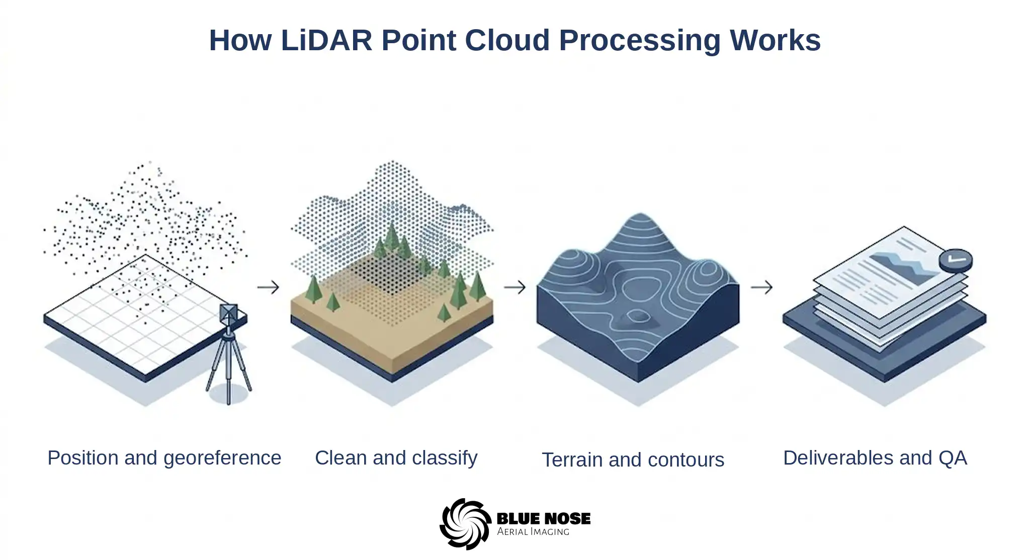
Step 1: Trajectory and Positioning
A LiDAR point is only meaningful if the exact position and orientation of the sensor at the instant of each pulse is known. Processing begins by reconstructing the aircraft’s flight path from the onboard satellite positioning and inertial measurement data, producing a precise trajectory for the mission. Every laser return is then placed relative to that trajectory. The quality of this step sets the ceiling for everything that follows.
Step 2: Georeferencing to Ground Control
The trajectory and point cloud are tied to ground control established on the site, so the data sits in the correct real-world coordinate system. Independent checkpoints, separate from the control used to adjust the data, are held back to verify the result. Checking the processed cloud against those checkpoints is how the partner confirms the data meets the project’s requirements, and Blue Nose Aerial Imaging of Tampa Bay documents that check so the licensed professional can evaluate the dataset against their own standard.
Step 3: Generating and Cleaning the Point Cloud
With positioning resolved, the individual returns are combined into a single dense point cloud. Processing then removes noise and outliers, such as stray returns from birds, dust, atmospheric particles, or reflective surfaces, that would otherwise distort the surface. The result is a clean cloud that represents the site rather than the artifacts of capture.
Step 4: Classification
Classification is where a raw cloud becomes useful. Each point is sorted into a category, such as ground, low and high vegetation, buildings, and other structures. The work is partly algorithmic and partly manual, because automated classification gets most of the way there and a trained editor resolves the cases the algorithm misreads, especially the boundary between low vegetation and true ground on a Florida site with heavy undergrowth. Good classification is the difference between a clean bare-earth model and one full of brush mistaken for terrain.
Step 5: Terrain and Surface Models
From the classified cloud come two models. The bare-earth digital terrain model uses only the ground points, representing the surface with vegetation and structures removed. The digital surface model includes everything, the tops of the canopy and the structures along with the ground. Surveyors and engineers usually work from the terrain model, while the surface model is useful for volume calculations the firm performs, clearances, and visualizing what sits on the site.
Step 6: Contours and Breaklines
Contour data at the interval the project requires is generated from the terrain model. Breaklines are added to capture the linear features that contours alone smooth over, such as ridges, ditch bottoms, curb lines, and edges of pavement, so the surface behaves correctly where the grade changes sharply. Breaklines are often what separates a contour deliverable an engineer trusts from one that needs rework.
Step 7: Deliverable Formats and Quality Assurance
The finished products are exported in the formats the firm’s software expects. Point clouds are typically delivered as LAS or compressed LAZ files, terrain and surface models as raster or gridded surfaces, and contours and breaklines in the CAD or GIS formats the firm uses, such as DWG, DXF, or shapefile. A quality-assurance summary documents how the data was controlled and how it checked against the independent checkpoints, so the firm has a record to evaluate before incorporating the data.
What to Specify When You Order
The cleanest deliverable comes from a clear specification at the start.
Coordinate system and datum
The coordinate system and datum the deliverable must sit in, so the data lands in the right real-world frame.
Point density
The point density the project needs, which drives the detail the cloud and the derived products can resolve.
Contour interval
The contour interval the deliverable calls for, set to the project rather than a default.
Breaklines
Whether breaklines are needed and for which features, so sharp grade changes are captured rather than smoothed.
Classification scheme
The classification scheme, so the points are sorted into the classes your workflow expects.
File formats
The exact file formats your software runs, so the deliverable drops straight in.
Blue Nose Aerial Imaging of Tampa Bay processes to that specification, which avoids rework and makes the handoff into the firm’s workflow direct.
Why Processing Quality Matters
Two LiDAR datasets from the same flight can differ enormously depending on processing. Weak positioning, sloppy classification, or missing breaklines produce a deliverable that looks complete and fails in use, when brush is mistaken for ground or a sharp grade change is smoothed away. Careful processing, checked against control, is what makes the data dependable enough for a licensed professional to seal work on. Blue Nose Aerial Imaging of Tampa Bay treats processing as the core of the deliverable, not an afterthought to the flight.
What It Costs and How to Engage
Point cloud processing is part of the LiDAR deliverable rather than a separate line, and LiDAR partnership missions typically range from $2,500 to $9,500 depending on acreage, point density, the deliverables, and site conditions. The LiDAR drone survey cost guide breaks those factors down in detail.
Frequently Asked Questions About LiDAR Point Cloud Processing
What is LiDAR point cloud processing?
LiDAR point cloud processing is the work of turning raw laser returns and sensor positions into usable data products. It reconstructs the sensor trajectory, ties the data to ground control, builds and cleans the point cloud, classifies the points, and produces terrain models, surface models, and contours. Most of a LiDAR deliverable’s value is created in processing, not in the flight.
What does point cloud classification mean?
It is the step that sorts every point into a class, ground, vegetation, building, and so on, so a clean bare-earth surface can be pulled out from the trees and structures above it. Software does the first pass and a trained editor fixes what it misreads, most often low brush sitting right at ground level on a Florida site.
What is the difference between a DTM and a DSM?
A DTM, the digital terrain model, is the bare ground with vegetation and structures stripped out. A DSM, the digital surface model, keeps everything in place, canopy and buildings on top of the ground. Design work usually runs off the DTM; the DSM is handy for the volume calculations the firm performs, for clearances, and for seeing what actually sits on the site.
What file formats can LiDAR deliverables be provided in?
Point clouds usually ship as LAS or compressed LAZ. Terrain and surface models come as raster or gridded surfaces, and contours and breaklines arrive in whatever CAD or GIS format the firm runs, such as DWG, DXF, or shapefile. Naming the formats at the start lets the data drop straight into your software.
How is the accuracy of processed LiDAR verified?
It is checked against independent ground checkpoints, ones deliberately held back from the points used to adjust the data, and that comparison shows how the dataset actually performs. Blue Nose Aerial Imaging of Tampa Bay documents the check so the surveyor or engineer of record can weigh it against the standard the project requires and decide whether it meets their needs.
Does Blue Nose Aerial Imaging of Tampa Bay process LiDAR for surveying firms across Florida?
Yes. Capture and processing are provided statewide as part of the LiDAR partnership program, with deliverables produced to the firm’s specification for incorporation under the firm’s seal.
Related guides
- Aerial LiDAR mapping in Florida
- Drone LiDAR services for surveying firms
- LiDAR drone surveys: what aerial data captures
- LiDAR drone survey cost
Chapter 472 Notice
Blue Nose Aerial Imaging of Tampa Bay provides aerial imagery, photogrammetric data products, and related reporting services for informational, operational, and documentation purposes only. Our deliverables, including orthomosaics, 3D models, point clouds, cut/fill reports, and stockpile inventory reports, are not survey products and are not intended for use in legal boundary determinations, property conveyances, permitting requiring licensed survey work, or any application governed by Chapter 472, Florida Statutes. Clients requiring licensed surveying and mapping services should engage a Florida-licensed surveyor and mapper. Blue Nose Aerial Imaging of Tampa Bay is not a licensed surveying and mapping firm and does not represent itself as such.
Scope Your LiDAR Deliverables

Rob Smith
Director of Operations, FAA Part 107 certified
To talk through processing requirements or scope a LiDAR project anywhere in Florida, see the LiDAR mapping service page, or talk it through with Rob Smith, our Director of Operations, on a call. Blue Nose Aerial Imaging of Tampa Bay works behind your seal as the aerial data partner.
What to expect on the call:
- We learn about the deliverable spec, the coordinate system and formats, and what your workflow needs.
- We capture and process the LiDAR to that spec, checked against independent checkpoints.
- You receive clean, classified, documented data products ready to incorporate under your seal.
You can also reach the team at 941-376-3396.