
Most construction professionals have heard the term Digital Elevation Model or its close relative, Digital Surface Model, but fewer can explain precisely what it contains, how it differs from an orthomosaic map, or at which point on a project timeline it becomes the most important data product on the site. This post answers all three questions without requiring a background in surveying or GIS. If you manage construction projects in Tampa Bay, Hillsborough County, Sarasota, or Manatee County and want to understand when elevation data earns its place in your workflow, this is a complete and practical guide.
Blue Nose Aerial Imaging of Tampa Bay produces Digital Surface Models as a standard deliverable alongside every orthomosaic mapping engagement. What follows reflects the real operational context in which that data is used by construction teams across Southwest Florida.
What a Digital Elevation Model Actually Is
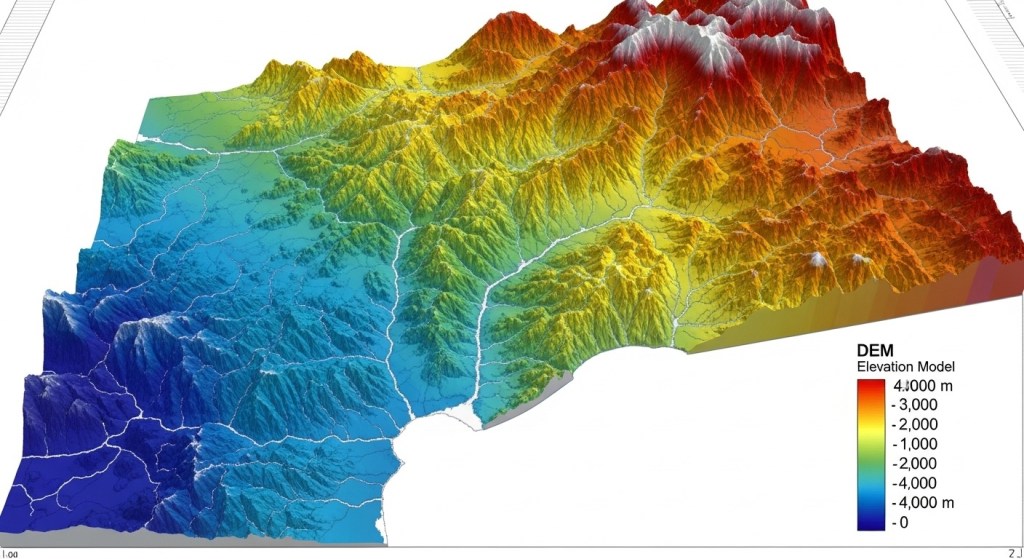
A Digital Elevation Model renders elevation as a colour gradient, making slope, drainage patterns, and surface variability immediately readable from above.
A Digital Elevation Model is a raster dataset in which every pixel stores an elevation value rather than a colour value. Where an orthomosaic shows you what a site looks like from above, its visual appearance, layout, and horizontal extent, a Digital Elevation Model shows you the height of every point across that same surface, measured from a consistent vertical datum.
In practical terms: load an orthomosaic into your GIS or CAD platform and you can see the site plan. Load a Digital Surface Model alongside it and you can extract an elevation reading from any location, generate contour lines at any interval, calculate slopes, identify drainage paths, and compute the volume difference between the current surface and a design model.
For the purpose of this post and consistent with what Blue Nose Aerial Imaging delivers the relevant product is a Digital Surface Model (DSM): an elevation model of the site surface as it currently exists, including all structures, stockpiles, and earthwork present at the time of capture. This is the appropriate deliverable for active construction site monitoring, earthwork verification, and grading compliance checks.
Note on terminology: “Digital Terrain Model” refers to a bare-earth model with above-ground features stripped out. Blue Nose Aerial Imaging produces Digital Surface Models, which record the actual site surface as captured, which is the operationally appropriate product for construction monitoring. Bare-earth terrain modelling is outside this service scope.
Digital Surface Model vs. Orthomosaic: Understanding the Difference
Both products are generated from the same drone flight and the same photogrammetric processing workflow. The distinction is in what each file contains and what questions it can answer.
Orthomosaic: what the site looks like
A geometrically corrected visual image with accurate horizontal positioning. Every pixel maps to a ground coordinate. Used for visual verification, overlay with design drawings, subcontractor documentation, and stakeholder reporting.
• Progress verification against site plan
• Subcontractor documentation and dispute prevention
• Executive and stakeholder reporting
• As-built visual record before phase transitions
Digital Surface Model: how high everything is
An elevation dataset in which every pixel stores a measured height value. Used for grading verification, drainage analysis, volume calculations, and comparison against design grades.
• Grading verification against design surface
• Cut-and-fill volume calculation
• Drainage and stormwater compliance review
• Contour line generation for engineering use
A project manager who only receives the orthomosaic has a visual record of the site. A project manager who receives both has a visual record and the ability to answer quantitative questions about elevation, slope, and volume, without sending a survey crew back to the site.
Florida-specific note: Florida’s relatively flat topography makes small elevation differences disproportionately important. A site that grades 0.5 percent incorrectly in the wrong direction can accumulate standing water, create drainage compliance issues under Hillsborough County or Southwest Florida Water Management District regulations, and require costly regrading. A Digital Surface Model captures these deviations across the full site extent, something a visual orthomosaic cannot do.
How a Digital Surface Model Is Produced from a Drone Flight

The same grid-pattern flight that produces an orthomosaic also generates the point cloud data from which a Digital Surface Model is derived, with no additional flight required.
The Digital Surface Model is not a separate product requiring a separate flight. It is derived from the same photogrammetric processing that generates the orthomosaic. During processing, Pix4D, the photogrammetric platform used by Blue Nose Aerial Imaging computes the three-dimensional position of every identifiable feature across the overlapping image set, producing a dense point cloud in which each point carries an X coordinate, a Y coordinate, and a Z (elevation) coordinate. The Digital Surface Model is derived by interpolating this point cloud into a regular raster grid.
The result is a GeoTIFF file that loads directly into AutoCAD Civil 3D, ArcGIS, QGIS, or any other GIS platform as a surface that can be queried, contoured, differenced against a design model, and used for stockpile inventory and cut-and-fill estimates all without any additional data collection or site access after the initial flight.
Accuracy specifications relevant to construction use
• Vertical accuracy – 3 to 8 cm typical under RTK conditions. Sufficient for grading verification, drainage review, and cut-and-fill estimation.
• Horizontal accuracy – 2 to 5 cm RTK-corrected. Positions elevation values within 2–5 cm of true ground coordinates.
• Ground sampling distance – as low as 1 cm per pixel, capturing small-scale surface variation and localised depressions or mounds.
• Delivery format – GeoTIFF. Loads directly into Civil 3D, ArcGIS, Global Mapper, and QGIS without conversion.
• Turnaround – 48 hours from flight. Available within the same weekly reporting cycle as the orthomosaic.
When a Construction Project Actually Needs a Digital Surface Model

Cut-and-fill volume calculations compare the current site surface against a design grade to quantify how much material needs to move, one of the most operationally valuable outputs of a Digital Surface Model.
Not every construction project needs regular Digital Surface Model capture. A structural build on a flat, previously graded pad with no ongoing earthwork may gain little additional value from elevation data that an orthomosaic alone does not provide. But the following project scenarios represent cases where a Digital Surface Model is not just useful, it is the difference between catching a problem early and paying to fix it late.
1. Pre-construction baseline capture
A Digital Surface Model captured before any earthwork begins establishes the verified existing conditions of the site surface. This baseline is used for all subsequent cut-and-fill calculations, provides the evidence base for comparing contractor invoices against actual ground moved, and serves as the pre-disturbance record for environmental and regulatory purposes. In Florida, where pre-construction drainage conditions are a factor in permitting and stormwater compliance, a documented baseline surface is directly valuable to the project’s regulatory record.
2. Grading verification during earthwork operations
This is the highest-frequency use case for active construction sites in the Tampa Bay region. A Digital Surface Model captured weekly or biweekly during grading operations allows the project engineer to compare the current surface elevation against the design grade at every point across the site. Deviations are identified and located precisely before the grading contractor moves to the next area of work, when correction is still inexpensive. After the grading contractor has moved on, bringing them back to correct a deviation costs significantly more.
3. Drainage and stormwater compliance review
Florida’s flat topography means that drainage performance is highly sensitive to small grade deviations. A Digital Surface Model allows the project engineer to generate contour lines, identify low and high spots relative to design, and confirm that the graded surface will perform as the stormwater management plan requires, before the site is paved or planted. This is particularly critical for projects in Hillsborough, Manatee, and Sarasota counties that fall under Southwest Florida Water Management District permit conditions.
4. Cut-and-fill quantity verification
Earthwork contractors invoice based on quantities of material moved. Those quantities are most accurately calculated by comparing the pre-work surface against the post-work surface using two Digital Surface Models from the same site. The volume difference between the two models, computed across the project area, yields the cut and fill quantities with a documented, reproducible basis that neither party can reasonably dispute.
5. As-built documentation before phase transitions
At the close of each earthwork or grading phase, a Digital Surface Model provides a verified elevation record of conditions before the next phase covers or permanently modifies the surface. This is particularly valuable before utility installation, slab pours, or paving operations that make subsequent verification impractical. The documented as-built surface supports warranty claims, change order substantiation, and future renovation planning.
Southwest Florida’s annual rainfall and drainage regulations make stormwater performance one of the most consequential grading outcomes on any commercial or residential development project. A Digital Surface Model that identifies a 0.3-foot low spot in a parking area before paving is a far less expensive problem than a standing water complaint after occupancy.
How Digital Surface Model Data Integrates Into Construction Workflows
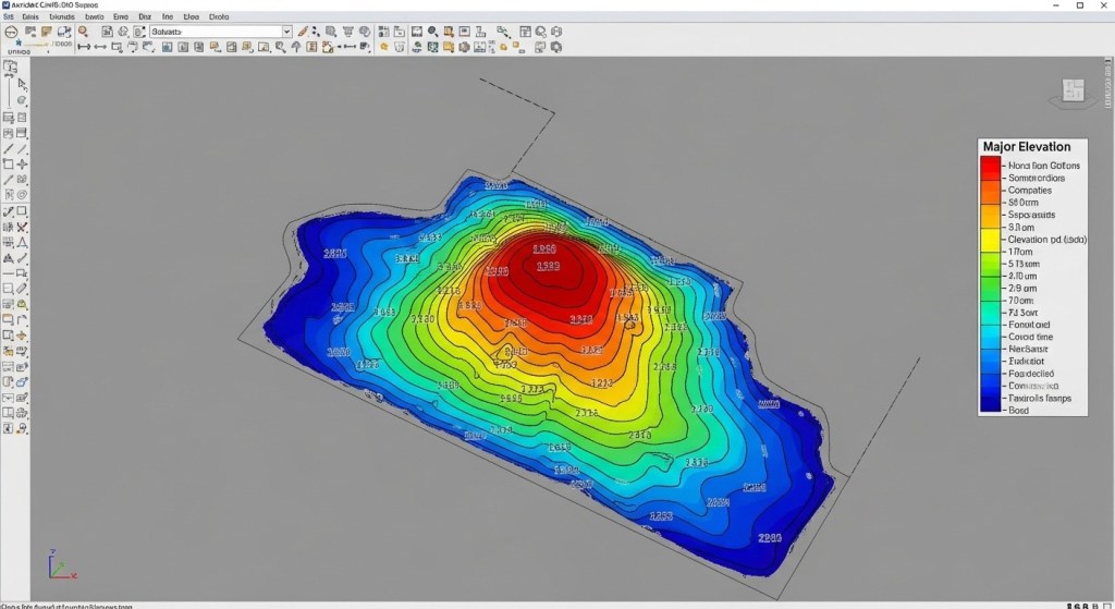
A Digital Surface Model loaded into AutoCAD Civil 3D, with contours generated and compared against the design surface to identify grade deviations across the full site.
AutoCAD Civil 3D
The GeoTIFF Digital Surface Model imports directly into Civil 3D as a surface that can be compared against design surfaces, used to generate contours, and analysed for volumes and grade deviations. Engineers already working in Civil 3D can load the file and begin querying elevation values and running comparisons without any additional processing steps.
ArcGIS and QGIS
GeoTIFF is the native raster format for both platforms. The Digital Surface Model loads as a georeferenced layer, allowing it to be combined with design data, utility maps, and other project layers. Slope maps, flow direction rasters, and cut-fill difference rasters can all be generated directly from the delivered file.
Procore
While Procore does not natively render elevation rasters for engineering analysis, the Digital Surface Model GeoTIFF can be stored in Procore’s document management system alongside the orthomosaic and other project files, ensuring that the elevation record is part of the centralised project documentation accessible to all team members.
Stockpile inventory analysis without additional software
For clients who need cut-and-fill quantities but do not have Civil 3D or GIS access, Blue Nose Aerial Imaging delivers stockpile inventory and cut-and-fill figures directly as an annotated PDF report with stockpile volumes, cut-and-fill totals, and surface comparison maps, requiring no client-side software to interpret. Related service: bluenosetampa.com/services/#Precision
What a Precision Mapping Engagement Delivers
Every precision mapping engagement from Blue Nose Aerial Imaging of Tampa Bay includes the Digital Surface Model alongside the full suite of mapping deliverables, produced from a single flight, delivered within 48 hours.
• RTK-corrected orthomosaic – GeoTIFF, JPG, and KMZ. Visual record with accurate horizontal positioning, compatible with CAD, Procore, and Google Earth.
• Digital Surface Model – GeoTIFF. Elevation dataset for the full site extent, ready for Civil 3D, ArcGIS, or QGIS.
• 3D mesh and textured model – OBJ, PLY, and DXF. For structural review, BIM integration, and complex site geometry visualisation.
• Stockpile and cut-and-fill figures – annotated PDF report with stockpile volumes, cut-and-fill quantities, and surface comparison maps.
• 48-hour delivery – via Google Drive, Dropbox, or direct transfer, formatted for the team’s existing workflow.
Related services: bluenosetampa.com/services/#Precision | bluenosetampa.com/services#Progress | bluenosetampa.com/services
Frequently Asked Questions
What is a Digital Elevation Model in the context of a construction project?
A Digital Elevation Model is a raster dataset that records the elevation of every point across a site surface. In construction, it is used to compare actual site grades against design grades, calculate earthwork volumes, identify drainage concerns, and verify that grading operations have been completed to specification. It is produced from the same drone flight that generates an orthomosaic map, no additional data collection is required.
What is the difference between a Digital Surface Model and an orthomosaic?
An orthomosaic is a visual image showing what the site looks like from above with accurate horizontal positioning. A Digital Surface Model is an elevation dataset recording the height of every point across the site surface. Both are produced from the same flight dataset using the same photogrammetric processing workflow. The orthomosaic tells you where things are horizontally; the Digital Surface Model tells you how high they are.
When does a construction project actually need a Digital Surface Model?
The most critical use cases are pre-construction baseline capture, grading verification during active earthwork, drainage and stormwater compliance review, cut-and-fill quantity verification, and as-built documentation before phase transitions. Projects involving significant earthwork, sloped or drainage-sensitive sites, or stormwater permit compliance in Florida benefit most from regular elevation data capture.
Request a Sample Deliverable or Get a Quote for Your Site
See the orthomosaic, Digital Surface Model, and stockpile report format before committing to an engagement. Blue Nose Aerial Imaging serves construction teams and developers across Hillsborough, Pinellas, Manatee, and Sarasota counties.
Request a Precision Mapping Quote: growth.bluenosetampa.com/quote-construction
Related guide: Drone mapping in Tampa Bay