
Radiometric aerial thermal inspections across Florida, for moisture on commercial roofs, faults across solar arrays, and heat loss on building envelopes.

Heat tells a story that visible light cannot. A wet patch of roof insulation, a failed solar cell in the middle of a thousand-panel array, a gap where a building’s insulation is missing: none of these are visible in an ordinary photograph, and all of them show up clearly in a thermal image. Drone thermal imaging puts a radiometric thermal sensor in the air, which makes it practical to scan an entire commercial roof, a utility-scale solar field, or a tall building facade in a single flight, and to find the problems while they are still cheap to fix.
This guide covers the three commercial applications that drive most thermal work in Florida, which are commercial roofs, solar installations, and building envelopes. It explains what each scan detects, how the data is captured correctly, and what the results can and cannot tell you.
What Drone Thermal Imaging Actually Is
A thermal sensor measures infrared energy, which corresponds to surface temperature, and turns it into an image where temperature differences appear as differences in color or brightness. A radiometric thermal sensor goes a step further and records the actual temperature value at every pixel, so the data can be analyzed and compared rather than only looked at.
Mounted on a drone, that sensor captures the same kind of overlapping grid a visual mapping flight uses, and the individual thermal frames are stitched into a thermal orthomosaic, a single temperature map of the whole roof, array, or facade. The result is a documented, located, temperature-referenced record, not a handful of handheld snapshots.
The difference between a radiometric sensor and a basic colorized one matters. A colorized thermal camera produces an image you can look at. A radiometric sensor produces documented temperature values, which is what an electrical contractor, roofing professional, or energy consultant needs in order to act. Blue Nose Aerial Imaging of Tampa Bay flies radiometric thermal payloads for that reason.
Commercial Roofs: Finding Trapped Moisture
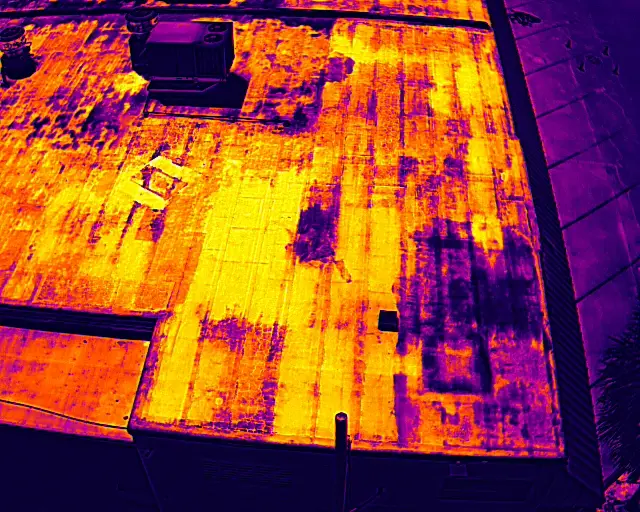
On a commercial roof, thermal imaging finds wet insulation under an intact membrane. After a day of sun, water-saturated insulation holds heat longer than dry insulation, so an evening thermal scan shows the wet areas as warm signatures against the cooler dry roof. That map shows the extent of trapped moisture before it becomes a visible leak, so a repair can be scoped to the actual wet area instead of guessed at.
This is the single most common thermal application Blue Nose Aerial Imaging of Tampa Bay flies, and the commercial roof inspection guide covers it in depth. Thermal turns a roof from a guessing game into a documented map of where the water is.
Solar Farms and Commercial Solar: Finding Faulty Panels
A solar array is only as productive as its weakest components, and a single failed cell, a tripped bypass diode, or a disconnected string can drag down the output of a whole section while everything looks fine from the ground. Thermal imaging finds those faults, because a panel or cell that is not converting sunlight into electricity turns it into heat instead and shows up hotter than its neighbors.
A drone thermal scan flies the array under load on a clear day with strong sun, and the thermal orthomosaic reveals the failures as bright anomalies: a single hot cell, a hot diode, a warm junction box, or an entire string sitting dark and hot. On a utility-scale field with tens of thousands of panels, finding those failures by hand with a clipboard and a handheld camera is impractical. A drone covers the whole field in a structured flight and produces a map that points maintenance crews directly to the panels that need attention.
Florida’s solar capacity has grown quickly, on commercial rooftops, carports, and large ground-mounted fields, and thermal inspection is how operators keep that capacity producing. The scan documents which components are running hot. The electrical contractor or asset operator interprets the anomalies and makes the repair or warranty call.
Building Envelopes: Finding Heat Loss and Air Leakage
A building’s envelope is its outer shell of walls, windows, and roof, and the envelope is where conditioned air is won or lost. Thermal imaging of a commercial facade shows where insulation is missing or wet, where air leaks around windows and joints, and where thermal bridging pulls heat through the structure.
For an energy retrofit, a commissioning check on a new building, or a diagnosis of why a tenant space will not hold temperature, a drone thermal scan of the facade gives an energy professional a documented picture of where the envelope is failing. The drone reaches the upper floors of a tall building that would otherwise require lifts or rope access, and it captures the whole facade consistently rather than one accessible section at a time.
In Florida’s climate, the envelope question is usually about keeping heat and humidity out rather than keeping warmth in, but the thermal signature of a failure is the same, and the scan documents it the same way.
How Thermal Imaging Is Done Correctly
Thermal results are only as good as the conditions and the equipment behind them, and this is where operator experience separates a useful dataset from a misleading one. Three things determine whether a thermal scan is worth anything.
Timing and conditions
A roof scan needs a full day of sun followed by an evening flight, so the moisture signatures have time to appear. A solar scan needs strong, steady sunlight and the array under load, so the faults run hot. An envelope scan needs a meaningful temperature difference between inside and outside. Flying at the wrong time produces a flat, useless image.
Radiometric data and calibration
The sensor needs to record real temperature values, and it needs to be set up correctly for the surface being measured, so the anomalies are genuine and not artifacts of reflection or a wrong emissivity setting.
Pilot judgment
A trained operator knows how to read the conditions, plan the flight for even coverage, and recognize when the data is clean enough to deliver. Blue Nose Aerial Imaging of Tampa Bay flies thermal work with that discipline, under FAA Part 107 authority and an aviation-grade approach to planning and safety.
What a Thermal Scan Documents, and What It Does Not
A drone thermal scan documents temperature patterns. On a roof, those patterns are consistent with trapped moisture. On a solar array, they indicate components running hotter than their neighbors. On a facade, they show where heat is moving through the envelope.
What the scan does not do is make the final professional determination. The roofing contractor confirms the repair scope, the electrical contractor or solar operator confirms the panel fault, and the energy professional interprets the envelope findings. Blue Nose Aerial Imaging of Tampa Bay delivers the documented thermal data, and the qualified professional reads the anomalies and makes the call. That division keeps the data useful and the responsibility where it belongs.
Why Blue Nose Aerial Imaging of Tampa Bay for Drone Thermal Imaging in Florida
Thermal imaging rewards experience and the right equipment, and it punishes shortcuts. Blue Nose Aerial Imaging of Tampa Bay flies radiometric thermal payloads, plans each scan for the conditions that make the signatures clear, and delivers the data in a form a professional can act on.
Our Director of Operations holds a master’s degree in Aeronautics with a specialization in Aviation Human Factors, an FAA Part 107 remote pilot certificate, and a current Airline Transport Pilot certificate as a 747 captain. Thermal inspection of roofs, solar installations, and building envelopes is available across Florida, since this work often takes Blue Nose Aerial Imaging of Tampa Bay well beyond the Tampa Bay no-mileage area to solar fields and commercial portfolios statewide.
What It Costs and How to Start
Thermal inspection falls within the same range as other commercial aerial data capture, typically $750 to $3,500 per site, with larger solar fields and multi-building portfolios scoped individually. The drone roof inspection cost guide covers the factors in detail.
Frequently Asked Questions About Drone Thermal Imaging
What is drone thermal imaging?
Drone thermal imaging mounts a radiometric thermal sensor on an uncrewed aircraft to record surface temperature across a roof, solar array, or building facade. The individual thermal frames are stitched into a single temperature map, which reveals problems that visible light cannot show, such as trapped roof moisture, failing solar components, and heat loss through a building envelope.
What can thermal imaging detect on a commercial roof?
Trapped moisture. Wet insulation under an intact membrane stays warm into the evening after a sunny day, so a thermal scan flags it as a warm signature and maps how far it has spread, well before it shows up as a ceiling leak. The commercial roof inspection guide goes deeper on the roofing use.
How does drone thermal imaging inspect solar farms?
Bad components run hot. A dead cell, a tripped diode, or a disconnected string turns sunlight into heat instead of power, so it shows up bright against its neighbors. One flight under strong sun and load maps every hot spot across the array, which beats walking tens of thousands of panels with a handheld camera.
Can thermal imaging find heat loss in a commercial building?
Yes. On a facade, the scan shows missing or wet insulation, air leaks at windows and joints, and thermal bridging that pulls heat through the shell. Energy pros lean on that for retrofits, new-building commissioning, and figuring out why a tenant space will not hold temperature.
When is the best time of day for a thermal scan?
It varies by target. Roof moisture shows up best in an early-evening flight after a sunny day. Solar wants midday sun with the array under load. Envelope scans need a real indoor-outdoor temperature gap. Fly at the wrong time and the image comes back flat, with nothing useful in it.
Does Blue Nose Aerial Imaging of Tampa Bay offer drone thermal imaging across Florida?
Yes, statewide. Thermal jobs regularly take Blue Nose Aerial Imaging of Tampa Bay well past the Tampa Bay no-mileage counties to solar fields and commercial portfolios across Florida, so roofs, arrays, and envelopes are all covered wherever the project sits.
How much does a drone thermal imaging inspection cost?
Thermal work runs in the same $750 to $3,500 per-site band as other commercial aerial capture, set by the size of the target and the deliverable. Large solar fields and multi-building portfolios are quoted individually, and the drone roof inspection cost guide breaks the factors down.
Request a Thermal Imaging Quote

Rob Smith
Director of Operations, FAA Part 107 certified
Every thermal imaging project starts with a quick conversation. Rob Smith, our Director of Operations, will help you scope the right scan for your roof, solar array, or facade and answer your questions on a call.
What to expect on the call:
- We learn about the target, whether it is a roof, a solar array, or a building envelope, and what you need the scan to show.
- We recommend the right thermal approach and timing for clear results.
- You get a clear, no-pressure quote.
You can also reach the team at 941-376-3396.